- Volga River
Geobox River
name = Volga River
native_name = Волга
other_name =
other_name1 =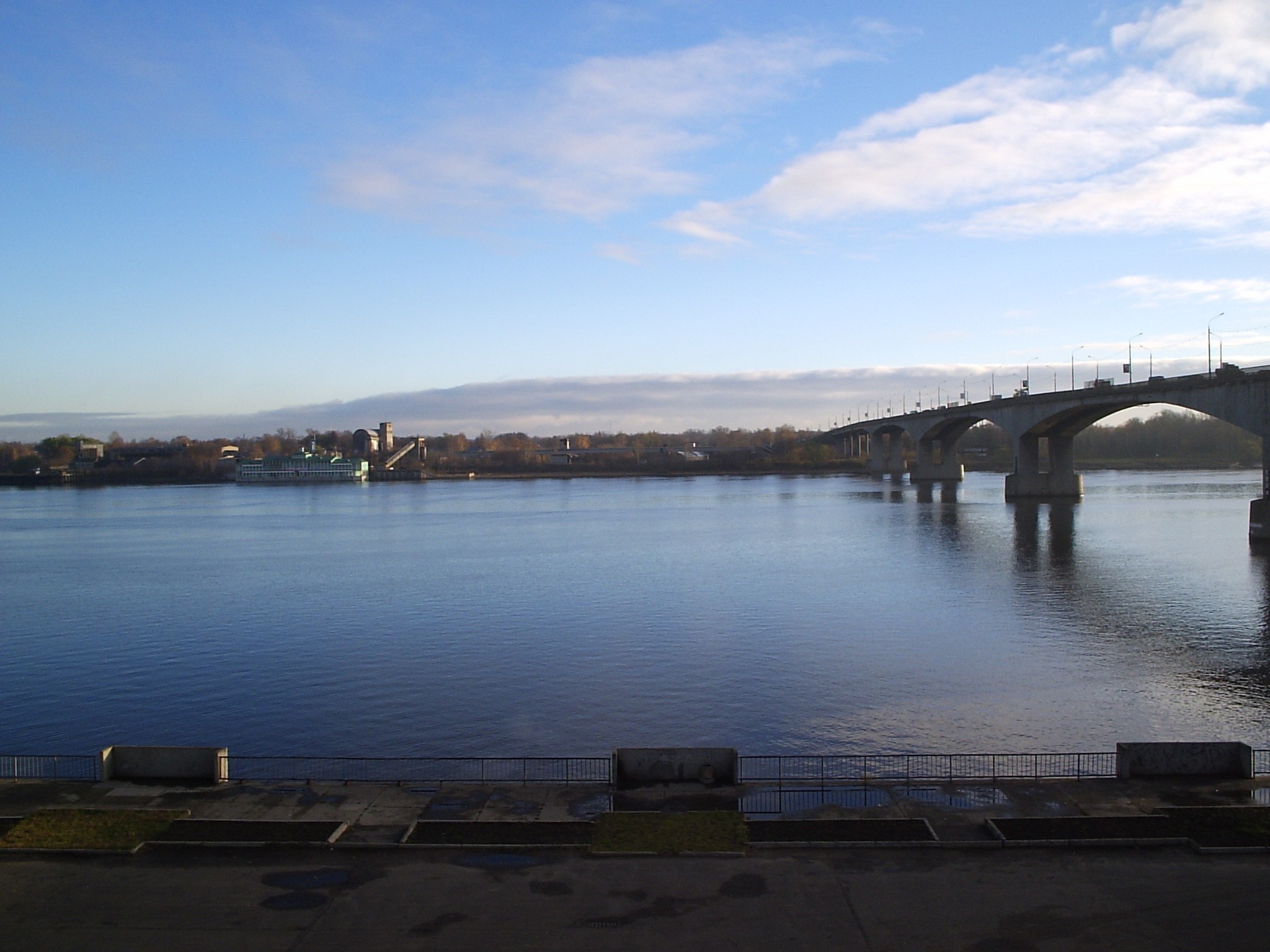
image_size = 300
image_caption = Volga inYaroslavl (autumn morning)
country =Russia
country1 =
state =
state1 =
region =
region1 =
district =
district1 =
city =Astrakhan
city1 =Volgograd
city2 = Samara
city3 =Kazan
city4 =Ulyanovsk
city5 =Nizhny Novgorod
city6 =Yaroslavl
length = 3692
watershed = 1380000
discharge_location =Volgograd
discharge = 8060
discharge_max =
discharge_min =
discharge1_location =
discharge1 =
source_name =
source_location =Valdai Hills
source_district =
source_region =Tver Oblast
source_state =
source_country =
source_lat_d =
source_lat_m =
source_lat_s =
source_lat_NS =
source_long_d =
source_long_m =
source_long_s =
source_long_EW =
source_elevation = 225
source_length =
mouth_name =Caspian Sea
mouth_location =
mouth_district =
mouth_region =Astrakhan Oblast
mouth_state =
mouth_country =
mouth_lat_d =
mouth_lat_m =
mouth_lat_s =
mouth_lat_NS =
mouth_long_d =
mouth_long_m =
mouth_long_s =
mouth_long_EW =
mouth_elevation = -28
tributary_left =Kama River
tributary_left1 =
tributary_right =Oka River
tributary_right1 =
free_name =
free_value =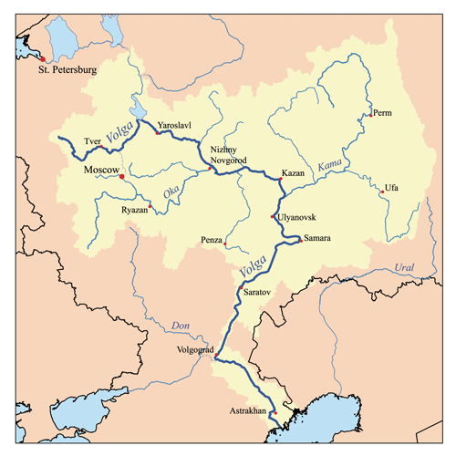
map_size = 300
map_caption = Map of the Volga watershed The Volga ( _ru. Волга, _tt. Идел|İdel) is the largestriver inEurope in terms of length, discharge, and watershed. It flows through the western part ofRussia , and is widely viewed as the national river of Russia. In fact, eleven out of the twenty largest cities of Russia, including its capitalMoscow , are situated in the Volga basin. Some of the largestreservoir s in the world can be found along the Volga.Nomenclature
The Russian hydronym " _ru. Волга" is akin to the Slavic word for "wetness", "humidity" (влага, волога). [See
Max Vasmer 's dictionary under "Волга".] The Russian name is transliterated as "Volga" in English and "Wolga" in German.The
Turkic people living along the river formerly referred to it asItil orAtil (probably the origin ofAttila 's name). In modernTurkic languages , the Volga is known as "İdel" (Идел) in Tatar, "Idyll" in ancient Chuvash-Bolgar, Атăл ("Atăl") in Chuvash, "Idhel" in Bashkir, and "İdil" in Turkish. The Turkic peoples associated the Itil's origin with theKama River . Thus, a right tributary to the Kama river was named the Aq Itil ("White Itil").Another version of the same root is represented by Mari Юл ("Jul"). Under the Mongols, the river was known by its other Turkic name "Sarı-su" ("yellow water") but Mongols used also their own name "Shar mörön" ("yellow river").
The ancient and modern Mordvin name for the Volga, Рав ("Rav"), apparently reflects the ancient
Scythian hydronym "*Rhā", supposedly cognate with the ancientAvestan andSanskrit names "Rañha" and "Rasah" for a mythical river supposed to flow around the earth [Lebedynsky, Iaroslav. "Les Sarmates : Amazones et lanciers cuirassés entre Oural et Danube". Paris: Editions Errance, 2002.] . It has even been suggested that the name Russian itself might have been derived from Rasah/Rosah, theIranic name of the Volga River (by F.Knauer Moscow 1901). TheseIranic words are all connected in their primary meaning of "dew, liquid, moisture".'Rasa' in Lithuanian language means a dew and 'Vilga' means to moisten or to damp...and 'Rusenti, Rusne' means to flow (like Baltic tribe 'Prussians' comes from 'Parusne, prusne' and even a word to bath 'prausti' comes from this root). It's obvious that both Lithuania and Rus or Russia mean the people who lives on the banks of rivers ('Lietuva' directly means the river's channel and 'lietis' means to flow or to pour, and 'lietus' means the rain)Or|date=September 2008
Description
The Volga belongs to the closed basin of the
Caspian Sea . Rising in theValdai Hills m to ft|225 above sea level north-west ofMoscow and about km to mi|320 south-east ofSaint Petersburg , the Volga heads east pastLake Sterzh ,Tver ,Dubna ,Rybinsk ,Yaroslavl ,Nizhny Novgorod , andKazan . From there it turns south, flows pastUlyanovsk ,Tolyatti , Samara,Saratov andVolgograd , and discharges into the Caspian Sea belowAstrakhan at m to ft|28 below sea level. At its most strategic point, it bends toward the Don ("the big bend"). Volgograd, formerly Stalingrad, is located there.The Volga has many
tributaries , most importantly the Kama, the Oka, the Vetluga, and the Sura rivers. The Volga and its tributaries form the Volga river system, which drains an area of about 1.35 million square kilometres in the most heavily populated part of Russia. TheVolga Delta has a length of about 160 kilometres and includes as many as 500 channels and smaller rivers. The largest estuary in Europe, it is the only place in Russia wherepelican s,flamingo es, and lotuses may be found. The Volga freezes for most of its length during three months of each year.The Volga drains most of Western Russia. Its many large reservoirs provide
irrigation and hydroelectric power. TheMoscow Canal , theVolga-Don Canal , and theVolga-Baltic Waterway form navigablewaterway s connecting Moscow to theWhite Sea , theBaltic Sea , theCaspian Sea , theSea of Azov and theBlack Sea . High levels of chemical pollution currently give cause for environmental concern.The fertile river valley provides large quantities of wheat, and also has many mineral riches. A substantial petroleum industry centres on the Volga valley. Other minerals include natural gas, salt, and potash. The Volga Delta and the nearby
Caspian Sea offer superb fishing grounds.Astrakhan , at the delta, is the centre of thecaviar industry.Confluents (downstream to upstream)
[

Zubtsov , circa 1910]
*Akhtuba (near Volzhsky), adistributary
*Samara (in Samara)
*Kama (south ofKazan )
*Kazanka (inKazan )
*Sviyaga (west ofKazan )
*Vetluga (nearKozmodemyansk )
*Sura (inVasilsursk )
*Kerzhenets (nearLyskovo )
*Oka (inNizhny Novgorod )
*Uzola (nearBalakhna )
*Unzha (near Yuryevets)
*Kostroma (inKostroma )
*Kotorosl (inYaroslavl )
*Sheksna (inCherepovets )
*Mologa (nearVesyegonsk )
*Kashinka (nearKalyazin )
*Nerl (near Kalyazin)
*Medveditsa (nearKimry )
*Dubna (inDubna )
*Shosha (nearKonakovo )
*Tvertsa (inTver )
*Vazuza (inZubtsov )
*Selizharovka (inSelizharovo )Reservoirs (downstream to upstream)
A number of large hydroelectric reservoirs were constructed on the Volga during the Soviet rule. They are:
*Ivankovo Reservoir
*Uglich Reservoir
*Rybinsk Reservoir
*Gorky Reservoir
*Cheboksary Reservoir
*Kuybyshev Reservoir ndash the largest in Europe by surface
*Saratov Reservoir
*Volgograd Reservoir Human history
The downstream of the Volga, widely believed to have been a cradle of the Proto-Indo-European civilization, was settled by Huns and other Turkic peoples in the first millennium AD, replacing
Scythians . The ancient scholarPtolemy of Alexandria mentions the lower Volga in his "Geography" (Book 5, Chapter 8, 2nd Map of Asia). He calls it the "Rha", which was the Scythian name for the river. Ptolemy believed the Don and the Volga shared the same upper branch, which flowed from theHyperborean Mountains.Subsequently the river basin played an important role in the movements of peoples from Asia to Europe. A powerful polity of
Volga Bulgaria once flourished where the Kama river joins the Volga, whileKhazaria controlled the lower stretches of the river. Such Volga cities asAtil ,Saqsin , or Sarai were among the largest in the medieval world. The river served as an important trade routeconnecting Scandinavia, Rus', and Volga Bulgaria with Khazaria and Persia.Khazars were replaced by
Kipchaks ,Kimeks andMongols , who founded theGolden Horde in the lower reaches of the Volga. Later their empire broke into theKhanate of Kazan andKhanate of Astrakhan both of which were conquered by the Russians in the course of the 16th centuryRusso-Kazan Wars . The Russian people's deep feeling for the Volga finds echoes in their culture and literature, starting from the 12th-centuryLay of Igor's Campaign . [ [http://www.volgawriter.com/VW%20Volga%20River.htm Volga River ] ]The Volga Boatmen's Song is one of many songs devoted to the national river of Russia.Construction of Soviet dams often involved enforced resettlement of huge numbers of people, as well as destruction of their historical heritage. For instance, the town of
Mologa was flooded for the purpose of constructing theRybinsk Reservoir (then the largest artificial lake in the world), and the construction of theUglich Reservoir entailed the flooding of several monasteries with buildings dating from the 15th and 16th centuries. In such cases the ecological and cultural damage often outbalanced any economical advantage. ["In all, Soviet dams flooded 2,600 villages and 165 cities, almost 78,000 sq. km. - the area of Maryland, Delaware, Massachusetts, and New Jersey combined - including nearly 31,000 sq. km. of agricultural land and 31,000 sq. km. of forestland". Quoted from: Paul R. Josephson. "Industrialized Nature: Brute Force Technology and the Transformation of the Natural World". Island Press, 2002. ISBN 1559637773. Page 31.]20th-century conflicts
During the
Russian Civil War , both sides fielded warships on the Volga. In 1918, the RedVolga Flotilla participated in driving the Whites eastward, from the Middle Volga at Kazan to the Kama and eventually toUfa on the Belaya River. [Brian Pearce , [http://www.marxists.org/history/ussr/government/red-army/1918/raskolnikov/ilyin/index.htm Introduction] toFyodor Raskolnikov s "Tales of Sub-lieutenant Ilyin."]In modern times, the city on the big bend of the Volga, currently known as
Volgograd , witnessed theBattle of Stalingrad , the bloodiest battle in human history, in which theSoviet Union and theNazi German forces were deadlocked in astalemate battle for access to the river. The Volga was (and still is) a vital transport route betweenRussia and theCaspian Sea , which provides access to the oil fields ofApsheron .Hitler planned to use access to the oil fields ofAzerbaijan to fuel future Nazi conquests. Apart from that, whoever held both sides of the river could move valuable troops and war machines, across the river, to defeat the enemy's fortifactions beyond the river. [ [http://www.historylearningsite.co.uk/battle_of_stalingrad.htm ::The Battle of Stalingrad:: ] ] By taking the river, Hitler's Germany would have been able to move supplies,gun s, and men into the northern part of Russia.For this reason, many
amphibious assaults where brought about in an attempt to remove the other side from the banks of the river. In these battles, The Soviet Union was the mainoffensive side, while the German troops used a moredefensive stance, though most the fighting was head on head, with no clear offensive or defensive side.Ethnic groups
The
Early East Slavs settled along the upper Volga in the 8th and 9th centuries, founding such towns asRostov (Sarskoe Gorodishche ) andYaroslavl (Timerevo ). In the course of several centuries they assimilated the indigenous Finnic population which included theMerya andMeshchera peoples. The surviving peoples of Volga Finnic ethnicity include the Maris andMordvins of the middle Volga.Apart from the
Huns , the earliest Turkic tribes arrived in the7th century and assimilated some Finnic and Indo-European population on the middle and lower Volga. TheChristian Chuvash andMuslim Tatars are descendants of the population of medievalVolga Bulgaria . Another Turkic group, theNogais , formerly inhabited the lower Volga steppes.The Volga region is home to a German minority group, the
Volga Germans .Catherine the Great had issued a Manifesto in 1763 inviting all foreigners to come and populate the region, offering them numerous incentives to do so. This was partly to develop the region but also to provide a buffer zone between the Russians and the Mongol hordes to the east. Because of conditions in German territories, the Germans responded in the largest numbers. Under theSoviet Union a slice of the region was turned into theVolga German Autonomous Soviet Socialist Republic to house many of the Volga Germans. Others were executed or dispersed throughout the Soviet Union prior to and afterWorld War II .Navigation
The Volga, widened for navigation purposes with construction of huge dams during the years of
Stalin 'sindustrialization , is of great importance to inland shipping and transport in Russia: all the dams in the river have been equipped with large (double) ship locks, so that vessels of considerable dimensions can actually travel from theCaspian Sea almost to the upstream end of the river.Connections with the Don River and the
Black Sea are possible through theVolga-Don Canal . Connections with the lakes of the north (Lake Ladoga ,Lake Onega ),Saint Petersburg and theBaltic Sea are possible through theVolga-Baltic Waterway ; and a liaison with Moscow has been realised by theMoscow Canal connecting the Volga and the Moskva rivers.This infrastructure has been designed for vessels of a relatively large scale (lock dimensions of 290 x 30 meters on the Volga, slightly smaller on some of the other rivers and canals) and it spans many thousands of kilometers. A number of formerly state-run, now mostly privatized, companies operate passenger and cargo vessels on the river;
Volgotanker , with over 200petroleum tanker s, is one of them.In the later Soviet era, up to the modern times,
grain andoil have been among the largest cargo exports transported on the Volga. [ [http://www.sciencedirect.com/science?_ob=ArticleURL&_udi=B6VH4-442YC33-6&_user=10&_rdoc=1&_fmt=&_orig=search&_sort=d&view=c&_acct=C000050221&_version=1&_urlVersion=0&_userid=10&md5=ff2c77e5d18e285e9b053e7a6d3c0509] ] Until recently access to the Russian waterways was granted to foreign vessels on a only very limited scale. The increasing contacts between theEuropean Union and Russia have led to new policies with regard to the access to the Russian inland waterways. It is expected that vessels of other nations will be allowed on the Russian rivers soon. [ [http://www.noordersoft.com/indexen.html NoorderSoft Waterways Database)] ]ee also
*
*Rivers of Russia
*Volga River Steamers References
External links
* [http://earthtrends.wri.org/maps_spatial/maps_detail_static.cfm?map_select=339&theme=2 Information and a map of the Volga's watershed]
* [http://earthfromspace.photoglobe.info/spc_volga_delta.html Volga Delta from Space]
* [http://as-volga.com Photos of the Volga coasts]
* [http://cabri-volga.org "CABRI-Volga": EU-Russian project on environmental risk management in the Volga Basin]
Wikimedia Foundation. 2010.