- Changde
-
For the Changde meteorite of 1977, see meteorite falls.
Changde
常德— Prefecture-level city — 常德市 Location of Changde within Hunan Location in China
 Changde
Coordinates: 29°02′N 111°41′E / 29.033°N 111.683°E Country China Province Hunan Area – Urban 1,061.3 sq mi (2,748.7 km2) – Metro 1,061.3 sq mi (2,748.7 km2) Population (2010 census) – Prefecture-level city 5,717,218 – Urban 1,232,182 – Urban density 1,161/sq mi (448.3/km2) – Metro 1,232,182 – Metro density 1,161/sq mi (448.3/km2) Time zone China standard time (UTC+8) Changde (Chinese: 常德; pinyin: Chángdé) is a city in the north of Hunan Province, China, with a population of 5,717,218 inhabitants at the 2010 census whom 1,232,182 in the built up area made of 2 urban districts (Dingcheng and Wuling).
Contents
History
Changde is known for its many Old Stone and New Stone Age sites. About 500 of them have been discovered to date.
In historical times it was also a centre from which governments controlled the mountain tribes of western Hunan. A county, named Linyuan, was established there in the 2nd century BC.
In 589 its name was changed to Wuling, and under the Tang Dynasty (618–907) it became the seat of Lang prefecture. Under the Song Dynasty (960–1279) the name of the prefecture was changed to Tingzhou, and in 1164–74 it became a superior prefecture called Changde. This status was retained until 1912, when the superior prefecture was abolished and the city became a county seat.
Qing
In the late 19th century Changde became a prosperous commercial center and the chief agricultural central market of the Yuan River basin. Many Chinese firms, and — after 1905, when it was opened to foreign trade — foreign firms as well, maintained branches there to buy rice, cotton, tung oil, and timber, so that Changde's economic influence reached out into northern Guizhou, southwestern Hubei, and parts of southeastern Sichuan province. The merchants of the Taho quarter of the city controlled much of the northwestern Hunan economy, and early in the 20th century Changde was the second city of Hunan, after Changsha.
Republic
Warlord Period
Unification & Japanese Occupation

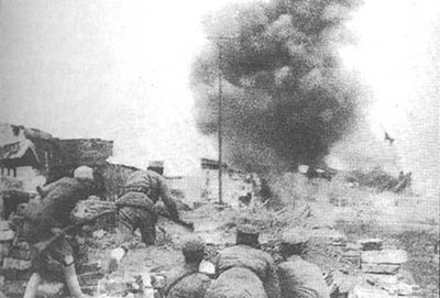
In the 1943 Battle of Changde, the Kuomintang's National Revolutionary Army attempted to stop the invading Japan Imperial troops from completing their invasion of Sichuan. Frustrated, the Japanese side employed chemical and biological weapons to clear their way. During the Khabarovsk War Crime Trials, proof was presented of operations to contaminate the area with plague as early as 1941 and 1942.
People's Republic
Although the commercial dominance of Changde firms disappeared with the advent of communist rule in 1949, the city remained an important center of trade, with the majority of its population engaged either in commerce or in transportation.
In 1975, Changde was hit by Typhoon Nina.
Geography
Situated on the north bank of the Yuan River above its junction with the Lake Dongting system, Changde is a natural center of the northwest Hunan plain. It has a monsoon-influenced, four-season humid subtropical climate (Köppen Cfa), with cool, often chilly, winters, and hot, humid summers. Monthly mean temperatures range from 4.7 °C (40.5 °F) in January to 28.6 °C (83.5 °F) in July.
Climate data for Changde (1971-2000) Month Jan Feb Mar Apr May Jun Jul Aug Sep Oct Nov Dec Year Average high °C (°F) 8.3
(46.9)10.0
(50.0)14.3
(57.7)21.3
(70.3)26.1
(79.0)29.3
(84.7)32.9
(91.2)32.2
(90.0)27.6
(81.7)22.4
(72.3)16.7
(62.1)11.4
(52.5)21.0 Average low °C (°F) 2.0
(35.6)3.7
(38.7)7.4
(45.3)13.6
(56.5)18.5
(65.3)22.2
(72.0)25.2
(77.4)24.9
(76.8)20.2
(68.4)14.8
(58.6)9.3
(48.7)4.2
(39.6)13.8 Precipitation mm (inches) 60.1
(2.366)67.1
(2.642)114.6
(4.512)169.6
(6.677)162.8
(6.409)208.9
(8.224)152.4
(6)129.9
(5.114)73.1
(2.878)81.4
(3.205)64.7
(2.547)38.9
(1.531)1,323.5
(52.106)% humidity 80 80 82 81 80 82 79 80 80 80 79 77 80.0 Avg. precipitation days 11.8 11.6 16.1 16.6 14.9 14.5 11.4 10.1 9.5 12.0 9.8 8.4 146.7 Sunshine hours 83.1 68.5 80.8 116.7 149.9 150.0 224.0 213.2 155.0 135.3 118.7 106.8 1,602.0 Source: 中国气象局 Administration
The municipal executive, legislature and judiciary is in Wuling District (武陵区), together with the CPC and Public Security bureau. Wuling sits on the left bank of the Yuanjiang River (沅江); opposite is the administrative centre for Dingcheng District (鼎城区).
Changde Municipality also oversees 2 districts, one county-level city and 6 counties :
- Wuling District
- Dingcheng District
- Jinshi City (津市市)
- Shimen County (石门县)
- Lixian County (澧县)
- Linli County (临澧县)
- Anxiang County (安乡县)
- Hanshou County (汉寿县)
- Taoyuan County (桃源县)
Economy
Today Changde is now an administrative centre and a storage and shipping point for tung oil, grain, cotton, medicinal herbs, and wood. Manufactures include ceramics, machine tools, textiles, leather, and processed foods. Grain, oil, cotton, and other commodities are loaded into medium-sized ships and taken to Yueyang, Changsha, or Hankou (Wuhan, Hubei province) for onward shipment. Timber is also rafted there and floated across Lake Dongting to Hueyang, and thus to the Yangtze River. After 1949 the city developed some light industry, mostly based on such local products as wood, leather, and bristles.
Transportation
Notes and references
In Changde also lives a famous singer Yao Zhiqiang.
External links
Hunan topics General Geography Cities • Yangtze River • Xiang River • Zijiang River • Yuanjiang River • Lishui River • Wuling Mountains • Xuefeng Mountains • Nanling Mountains • Luoxiao Mountains • Lake DongtingEducation Hunan University • Hunan University of Arts and Science • Hunan Normal University • Hunan Agricultural UniversityCulture Cuisine Visitor attractions Hunan Province county-level divisions Changsha: Yuelu District · Furong District · Tianxin District · Kaifu District · Wangcheng District · Yuhua District · Liuyang City · Changsha County · Ningxiang County Hunan in China
Zhuzhou: Tianyuan District · Hetang District · Lusong District · Shifeng District · Liling City · Zhuzhou County · You County · Chaling County · Yanling County
Xiangtan: Yuetang District · Yuhu District · Xiangxiang City · Shaoshan City · Xiangtan County
Hengyang: Yanfeng District · Zhuhui District · Shigu District · Zhengxiang District · Nanyue District · Changning City · Leiyang City · Hengyang County · Hengnan County · Hengshan County · Hengdong County · Qidong County
Yueyang: Yueyanglou District · Junshan District · Yunxi District · Miluo City · Linxiang City · Yueyang County · Huarong County · Xiangyin County · Pingjiang County
Shaoyang: Shuangqing District · Daxiang District · Beita District · Wugang City · Shaodong County · Shaoyang County · Xinshao County · Longhui County · Dongkou County · Suining County · Xinning County · Chengbu Autonomous County
Changde: Wuling District · Dingcheng District · Jinshi City · Anxiang County · Hanshou County · Li County · Linli County · Taoyuan County · Shimen County
Zhangjiajie: Yongding District · Wulingyuan District · Cili County · Sangzhi County
Yiyang: Heshan District · Ziyang District · Yuanjiang City · Nan County · Taojiang County · Anhua County
Chenzhou: Beihu District · Suxian District · Zixing City · Guiyang County · Yongxing County · Yizhang County · Jiahe County · Linwu County · Rucheng County · Guidong County · Anren County
Yongzhou: Lengshuitan District · Lingling District · Dong'an County · Dao County · Ningyuan County · Jiangyong County · Lanshan County · Xintian County · Shuangpai County · Qiyang County · Jianghua Autonomous County
Huaihua: Hecheng District · Hongjiang City · Hongjiang District · Yuanling County · Chenxi County · Xupu County · Zhongfang County · Huitong County · Mayang Autonomous County · Xinhuang Autonomous County · Zhijiang Autonomous County · Jingzhou Autonomous County · Tongdao Autonomous County
Loudi: Louxing District · Lengshuijiang · Lianyuan City · Shuangfeng County · Xinhua County
Xiangxi: Jishou City · Luxi County · Fenghuang County · Huayuan County · Baojing County · Guzhang County · Yongshun County · Longshan CountyCategories:- Changde
- Prefecture-level divisions of Hunan


Wikimedia Foundation. 2010.